Land
 Juneau landslides are often linked to intense precipitation events
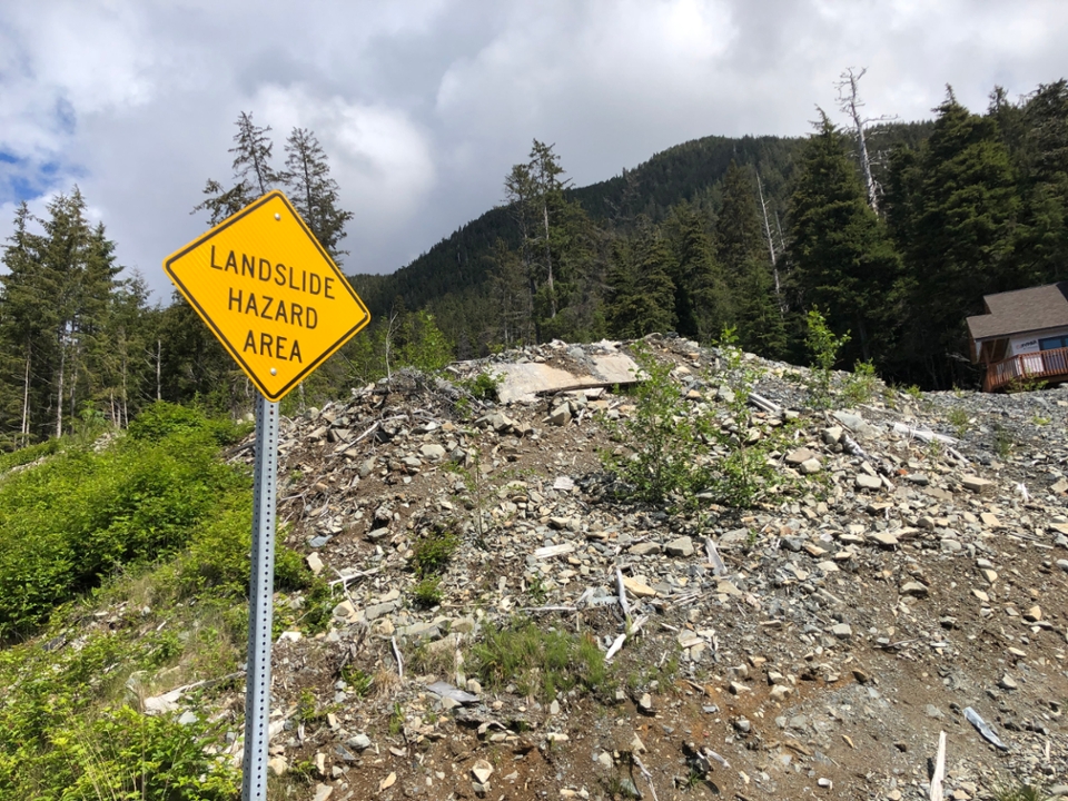
Landslides include many types of mass movements, ranging from dry rockfalls to torrential mudflows that release materials downslope, often in rapid pulses. In Juneau, the most common type of landslide hazard is a debris flow, although rockfalls and debris slides also commonly occur.1 Debris flows are turbulent mixtures of fine-to coarse grained soils, rocks, trees, and any other material that gets caught up in the flow of material released. Factors that contribute to debris flow potential include steep slopes, thick soils, freeze-thaw cycles, oversteepening of slopes, and prolonged or intense precipitation events. Landslide potential can build up over time, and debris flows can be triggered by heavy and/or prolonged precipitation, earthquakes, undercutting of slopes (e.g. by road cuts or stream erosion), and logging, all of which are factors in Juneau, which has an extensive history of landslides.1 Many of the historically known landslide events in Juneau over the past century are linked to episodes of high rainfall. Prolonged or intense precipitation can trigger landslides because as water saturates the soil, the pore pressure increases and the soil shear strength is weakened.2
Atmospheric rivers increase the risk of flooding and landslides
The most intense and prolonged high precipitation events in Juneau arrive in the form of atmospheric rivers (ARs).3 These are formed by the transport of tropical moisture poleward across the Pacific Ocean northward and over Southeast Alaska. These ARs are typically long, narrow plumes of enhanced atmospheric water vapor. They are identified and observed via integrated water vapor in satellite imagery and result in rainfall amounts of 2-9 inches, with some rates of >0.30 inches per hour or 3-6 inches per day. Often accompanying ARs are high winds, which can add further damage by loosening trees in saturation-compromised soils and starting a cascading effect downslope from a windfall.4 The impacts of ARs are exacerbated if they arrive onto already saturated soils, as is often the case in Juneau, especially in the fall season, or onto existing snowpack that can quickly melt when in contact with the warmer rainfall (as was the case in the December 2020 event), a process that increases the amount of surface runoff, intensifies flooding, and increases the risk of landslides.
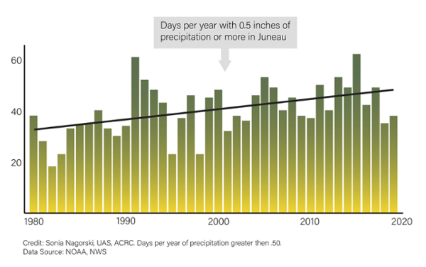
Figure 10. Days Per Year of Precipitation Greater Than .5 Inches
Climate data from the Juneau airport showing days per year of precipitation greater or equal to 0.50 inches with the black line representing the trend from 1980 to 2019. Extreme high precipitation events are major triggers for landslides. Source: McFarland (2019).
Southeast Alaska has experienced fatalities and significant property damage due to atmospheric rivers
Atmospheric river events have caused hillslope failures in Southeast Alaska in the recent past, such as in Sitka in 2015, when an AR caused over 40 landslides and 3 fatalities, in Haines in December 2020, when an atmospheric river dumped over 10 inches of rain onto snow-covered ground in 2 days, caused a major landslide, killing 2 residents. In Juneau, during the same December 2020 AR event, there was extensive flooding, debris flows, and property damage in the Juneau communities of Mountainside, Twin Lakes, Glacier Highway near downtown, and in the Salmon Creek watershed, where a landslide damaged the pipeline that supplies water to the DiPAC hatchery, resulting in the destruction of thousands of rearing fish.
As precipitation increases, atmospheric rivers are becoming more frequent on the west coast
As discussed in Section 3, Juneau is experiencing a trend toward higher precipitation due to the warming climate. Continued warming is expected to increase the total number of atmospheric rivers that impact the west coast of North America.5 Trends of annual precipitation across Southeast Alaska from 1969 to 2018 show increases ranging from 4.7% to 15.1%.6 There is an increasing trend from 1980 to 2019 in the number of days per year that the Juneau International Airport received more than 0.50 inches of precipitation. Maximum consecutive 3-day precipitation amounts are projected to increase from 2031 to 2060, and these events typically occur in the autumn and early winter and are frequently associated with atmospheric rivers, which would relate to an increase in flood risk and, in turn, landslides.7
With each atmospheric river, risk of landslide activity is renewed, particularly if soils are already saturated from prior rainfall events. Other hazards linked to intense storms and atmospheric rivers include endangerment of the integrity of the Salmon Creek dam, flooding of streamside neighborhoods, overwhelming of storm drains and other infrastructure, road erosion, and endangering safe passage on roads and bridges.
Juneau infrastructure is increasingly susceptible to landslides
In 2021, a CBJ-commissioned study found that about half of Juneau’s downtown buildings are located in areas of moderate to severe risk of landslides or avalanches.1 Not all parts of Juneau are equally susceptible to debris flows; those at greatest risk are likely at the base of steep, undercut slopes made up of deep, unconsolidated soils atop weak geologic materials and that are proximal to gully or stream channels draining the slopes. Landsliding is a natural geological process in steep terrains such as that surrounding Juneau’s neighborhoods. However, as Juneau continues on its current trend of receiving higher amounts of precipitation, increased frequency of ARs, rain-on-snow, and other extreme weather events, all of which are triggers for landslides, it will likely experience a commensurate increase in landslide magnitude and frequency.
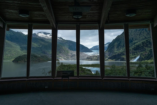
Mendenhall Glacier is a major tourist destination and a focal point of the Juneau community. The glacier has retreated since its Little Ice Age maximum in the late 1800s, and about 1.3 miles since the U.S. Forest Service Mendenhall Glacier Visitor Center (MGVC) was built in 1962.1 As a result of the glacier’s ongoing retreat, visitors now see a shrunken, narrower glacier with more bedrock exposed on either side of the lower glacier and less ice reaching and calving into Mendenhall Lake.
The glacier continues to retreat and thin at high rates, with some of the highest observed thinning rates occurring from 2014 to 2019 (averaging about 9.8 feet/yr across the glacier).2 When observed thinning rates are projected forward in time and applied to surface and bed elevation maps of the glacier,3,4 the glacier continues to retreat at rates of about 55 yards/year. Lower or higher thinning rates result in rates of terminus retreat of 20-80 yards/year. In moderate climate warming scenarios, the glacier will barely be visible from the MGVC by 2050.
Figure 11. Future Glacier Retreat
Artistic rendering of the view from the Mendenhall Glacier Visitor Center in 2040, based on the mid-range thinning rate scenario. Source: Amber Chapin, Michael Penn
Glacial lake outburst floods in Juneau
The retreat of Suicide Glacier, a former tributary to Mendenhall Glacier, has created an ice-dammed basin a few kilometers upstream from the Mendenhall Glacier terminus. Each summer since 2011 the basin has filled with water and drained catastrophically in glacier outburst floods (also known as jökulhlaups), that threaten downstream infrastructure. Because of interannual variability in the magnitude of the floods, it is challenging to assess and prepare for hazards.5 The magnitude of the floods depends on how much water can be stored in the basin, which depends on ice dam thickness and the amount of remnant ice left behind in the basin by the retreat of Suicide Glacier. Thinning of the ice dam that blocks water from escaping the basin decreases the storage capacity, whereas melting of the remnant ice floating in the basin increases the amount of water that can be held. Because we don’t know exactly how the drainage event begins, and the floods vary in magnitude from year to year, it is unclear whether floods from Suicide Basin will increase or decrease in size in the coming years.
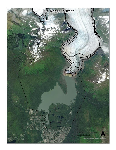
Figure 12. Mendenhall Glacier Retreat
Computed glacier outline in 2020, 2030, 2040, and 2050, from the mid-range thinning rate scenario. Source: Jason Amundson, Mike Hekkers
A globally significant carbon sink
The Tongass National Forest is a globally significant carbon sink. How we manage the forests in Southeast Alaska has far-reaching impacts on climate change. As natural buffers to rising greenhouse gas levels, forests can capture or store atmospheric carbon dioxide (sequestration), reducing the carbon in the atmosphere and mitigating the effects of global climate change.
Figure 13: Alaska and British Columbia Soil Carbon
Soil organic carbon stock predictions to 1 m (Mg C ha−1) at 90.5 m resolution for small NPCTR watersheds across BC and SE Alaska. Source: McNicol (2019)

Carbon research to inform forest management
Forests are important carbon pools that continuously exchange CO2 with the atmosphere, due to both natural processes and human action. Understanding how the forest participates in the greenhouse effect requires a better understanding of the carbon cycle at a local level. How the Tongass is used for timber, wildlife values, recreation and other uses will influence carbon sequestration rates. The Tongass National Forest is one of the most dynamic environments relative to the carbon cycle, with nearly nine times the amount of carbon dissolving in our streams as the Amazon River basin per unit area.1 Researchers are working to better understand the dynamics of carbon on the Tongass and how they impact the global carbon cycle. Understanding the carbon cycle and where and how long carbon is stored on land or in deep waters after flushing out of streams will inform forest management practices.
Climatic changes in Southeast Alaska are leading to shifts to plant species and abundance
Predicted changes in temperature and precipitation have implications for future alterations to both soils and plants in Southeast Alaska. Plant rooting depth responds to physical and chemical conditions in the soil surface. Tree species abundance is influenced primarily by soil hydrodynamics with Sitka spruce (Picea sitchensis) and western hemlock (Tsuga heterophylla) dominating the drier end of the spectrum, and red cedar (Thuja Plicata), yellow-cedar (Callitropsis Nootkatensis) and shore pine (Pinus contorta, contorta) found on wetter sites.2 One clear implication for change is in the abundance of yellow-cedar, which has experienced a dramatic decline due to the loss of protective snowpack over the past 100 years.3 Yellow-cedar is shallow rooted and vulnerable to soil freezing events that damage fine roots.4, 5 Projections for the region have varying rates of decline continuing, but the Juneau area has several refugial stands that have not been impacted by decline and are relatively stable.6 Red cedar has a similar rooting behavior but has not experienced the same extent of decline across the landscape. However, several red cedar flagging events have been noted in recent forest health surveys.7
Carbon stored in soil is on the move
Soils of the Southeast Alaska coastal rainforest store the majority of ecosystem carbon.8 Soil carbon is not static and is always undergoing changes due to the activity of microorganisms and tree roots.9 Organic matter is mineralized by microbes that use the reduced organic carbon as a source of energy and release plant-essential nutrients in the soil organic matter. Organic material can be deposited as leaf litter, woody debris, or soluble carbon consisting of organic acids leached from vegetation. The soluble organic acids pass through the organic horizon and flow downward to the lower soil horizons and can move carbon deeper into soil profiles. An emerging insight is the ephemeral nature of soil organic matter rather than long-term stable pools.10 Total soil carbon stock estimates for the coastal rainforest soils range from 1.9 to 4.8 petagrams of carbon (Pg C) with a total Tongass National Forest stock estimated at 2.8 Pg.8, 11
Increasing temperatures could drive soil decomposition
Juneau has a mix of mineral soils along with dense pockets of deep organic soil peatlands. In warming temperatures, peatland soils are susceptible to decomposition, releasing stored carbon back into the atmosphere.12 Predicted increases in air temperatures could cause a loss of stored organic matter in peatland and the organic material covering mineral soils. The decomposition is not always complete, and dissolved carbon can flow from soils to streams at different rates across watershed types, resulting in an uncertain influence on nearshore coastal resources.13
Weather extremes impact soil water storage, plant health, and stream ecosystems
Changes in precipitation as both snow and rain have led to extreme drought and floods due to large storms. Both of these climatic events have implications for soils and plants. Drought reduces the available water capacity in surface soils and the ability of trees to transpire. This has impacts on the tree itself and the soil water balance. Soil moisture deficit causes stress on the tree as it tries to pump water to the upper tissues, which can cause physiological stress and reduced growth and reproduction or, worse, the death of the plant. Soil moisture deficit is exacerbated by the pumping of water from the soil into the trees. During droughts, soil water storage can be reduced to a point where baseflow to streams is diminished or ceases entirely. Reduced detention storage from soils to streams reduces streamflow, which negatively impacts aquatic resources. The reduced soil moisture storage results in lower baseflow and discharge to streams. Reduced soil moisture supply to groundwater can also reduce streamflow, especially in back channels and low flow areas. Because these zones serve as important rearing areas for salmon, drought stress can lead to reduced fish production or hypoxia events and massive fish kills.14
In conclusion, both drought and storms provoke major responses in Juneau’s forests. Climate change brings impacts to trees, soils, streams, fish, and the ocean in a complex process that, under normal circumstances, would instead provide a huge amount of carbon.