Yakutat Stream Assessment
Yakutat Stream Assessment
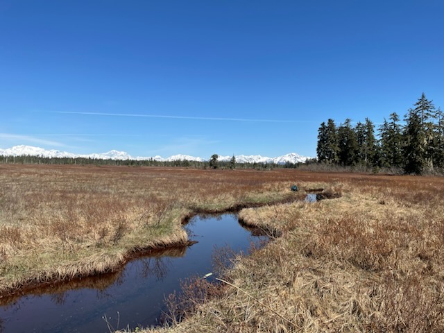
UAS researchers are working with local community members in Yakutat, Alaska, to investigate the relationship between landscape characteristics and stream temperatures using drone imagery and a network of temperature sensors across different aquatic habitats in the Situk River watershed.
With 9 native fish species and 10 times the density of juvenile coho salmon than any other Southeast Alaskan watershed, the Situk River is among the most productive resources in Alaska. The associated fisheries in the Situk River and its adjoining estuary drives a $2m economy for the community of Yakutat, with 89 percent of the households harvesting salmon for subsistence purposes. The Yakutat foreland area that encompasses the Situk River watershed is
a vast landscape of low gradient drainages with forested mosaics of side channels and pools that are responsible for up to 80% of coho production. These atypical yet highly productive aquatic habitats are known to be sensitive to even small shifts in temperature and elevational gradients, and therefore, highly vulnerable to future changes through climate fluctuations and uplift from glacial rebound. ACRC researcher Jason Fellman and affiiliate Ryan Bellmore, led by UAS researcher Sanjay Pyare are building a community-based partnership with tribal, non-government and state/federal agencies to collect and share temperature data, conduct technical training, and co-mentor local high school students transitioning to higher education.
The research objectives are to 1) increase understanding of within-watershed, thermal variability across the Situk River and its low-gradient tributaries; 2) derive temperature-driven developmental- and bioenergetics-based models to estimate salmon habitat quality across the diverse aquatic habitats of the Situk River watershed; and 3) acquire and apply drone imagery to understand how adjoining landscape characteristics affect thermal habitat for salmon.
Community interns will assist with sensor and drone-based data collection, help collect GPS data and validate temperature using spot measurements. This collaborative effort will allow identification of thermally vulnerable aquatic habitat under future climate-change scenarios, which we will in turn use to build community- and professional awareness about local climate vulnerabilities and build capacity for climate mitigation in the management of a culturally and socioeconomically critical resource.
Contact
- Sanjay Pyare (spyare@alaska.edu)
Project Team
- Jason Fellman (jbfellman@alaska.edu)
- J. Ryan Bellmore (US Forest Service) (james.r.bellmore@usda.gov)
Partners & Funders